
Yale Joins NOAA, NASA for Comprehensive Air Quality Research Campaign

Researchers from NOAA, NASA, Yale Engineering and 20 other universities from three countries are deploying state-of-the-art instruments in multiple, coordinated research campaigns this month to investigate how air pollution sources have shifted over recent decades.
Yale’s Drew Gentner, associate professor of chemical and environmental engineering and the environment, will lead ground measurement sites in New York and Connecticut to interpret air pollution transport from urban cities to downwind locations.
Since the 1970s, U.S. scientists and environmental regulators made significant strides in reducing air pollution by cleaning up tailpipe and smokestack emissions. Yet levels of two of the most harmful types of pollution, ground-level ozone and fine particulates, have decreased only modestly in recent years. Both still contribute to the premature deaths of more than 100,000 Americans every year.
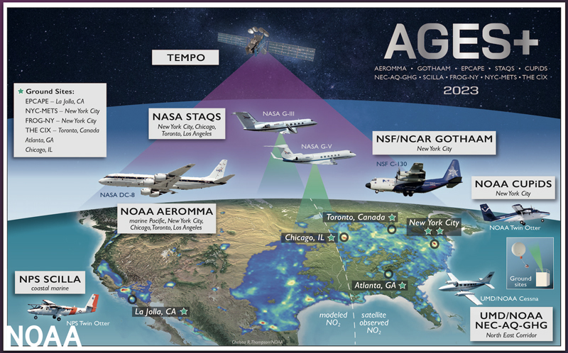 Using multiple satellites, seven research aircraft, vehicles, dozens of stationary installations — even instrumented backpacks — scientists will measure air pollution from sources that include transportation, industrial facilities, agriculture, wildfires and consumer products such as paint, pesticides and perfumes. The data will be scrutinized, analyzed and run through sophisticated chemical and weather models by scientists and the U.S. Environmental Protection Agency (EPA) in an effort to improve air pollution forecasts. Findings will be shared with state and local environmental officials to inform decisions about the most effective ways to reduce air pollution.
The data will also be used to evaluate the first observations made by NASA’s groundbreaking TEMPO instrument — the first geostationary space-borne sensor to continuously measure air pollution across North America. Lessons learned will aid the development of the new GeoXO satellites being jointly developed by NOAA and NASA.
“This is an unprecedented scientific investigation — in scope, scale and sophistication — of an ongoing public health threat that kills people every year,” said NOAA Administrator Rick Spinrad, PhD. “No one agency or university could do anything like this alone.”
Probing the causes of persistent pollution
Despite steady improvements, air pollution remains an issue in the US, with about 200 counties failing to meet national ozone standards and 69 not meeting fine particle (PM2.5) standards. The decrease in ground-level ozone and fine particle pollution has slowed in recent years.
Researchers from numerous NOAA research labs and research pilots are leading three of the research initiatives. Their largest project, AEROMMA, involves operating 30 specialized instruments aboard NASA’s DC-8 aircraft to study the chemical composition of the air over major cities including New York, Chicago, Detroit, Toronto, and Los Angeles.
While fossil fuel emissions were once the leading cause of volatile organic compounds (VOCs) that contribute to pollution, today, consumer products derived from fossil fuels may account for up to 50% of VOC emissions in densely populated urban cities, recent NOAA research shows. These are often overlooked in emissions inventories and air quality strategies.
Additionally, the team may study the impacts of wildfire smoke, another emerging source of air pollution that has significantly affected Midwest and East Coast states this summer.
Collecting data from the sidewalks to satellites
NASA researchers are also deploying two of their Gulfstream research aircraft with the DC-8, mapping air quality and methane from high altitudes over the five cities while the DC-8 collects measurements at lower altitudes. Similar to the other projects, data collected by NASA’s STAQS mission will be compared to TEMPO’s high-resolution estimates of trace gas and aerosols, as well as with emission inventories and atmospheric processes.
A concurrent NOAA research mission, CUPiDS, will study the atmospheric processes that generate and distribute pollutants across the New York metropolitan area and downwind over Southern New England. This includes coordinated measures from a University of Maryland instrumented Cessna aircraft and a NOAA-equipped SUV, capturing the vertical distribution of air pollution and greenhouse gas emissions from DC-Baltimore up to New York City and Long Island Sound.
On the ground, researchers from Yale Engineering’s Drew Gentner, Aerodyne Research Inc. and other NOAA-funded collaborators will be taking measurements from a rooftop site at the The City College of New York campus, downwind in Guilford, Connecticut, from a 62-meter research tower on Long Island, in coordination with the DC-8 and Twin Otter flights. NOAA’s Climate Program Office is providing major funding for these and other affiliated studies.
At ground level, researchers from Yale Engineering, Aerodyne Research Inc., and other NOAA-funded researchers will carry out measurements in New York and Connecticut, including a rooftop site at The City College of New York, downwind in Guilford, Connecticut, and a 62-meter research tower on Long Island, in coordination with the research aircrafts. These ground-level studies are key to understanding urban pollution and its wider impacts, particularly under changing climate conditions, explained Yale Engineering’s Drew Gentner, who is leading the ground operations.
“This regional network of ground sites has enormous potential to help us understand urban and downwind air pollution — not just today but under a continually changing climate,” Gentner said.
In Manhattan, scientists will be carrying air pollution sensors in backpacks in a NOAA pilot project to investigate surface ozone and PM2.5 in underserved neighborhoods in New York City, where pollution directly impacts human health, especially during heat wave events.
Tying it all together
“The large number of participants, measurements, the variety of platforms involved, and the way they are working together in a highly choreographed and coordinated way is unique,” said NOAA’s Chemical Science Laboratory Director David Fahey. “Our goal is a comprehensive view of air pollution spanning the U.S. to improve forecasts of urban and regional air quality and advance the health of our nation.”